NAV buttons
Palia Park Triple Loop Bicycle Tour
Biking Palia Park and it’s surrounding neighborhoods
The Park
Located in the heart of Ocean Township is Joe Palia Park (aka Deal Test Site). This central park is the township’s outdoor recreation jewel; among its trees, baseball, soccer, and festival fields winds a 3 mile multi use paved path with many parking and access points along the route. This central location makes possible a ride up to 25 miles without leaving the township’s boundaries. In addition Palia Park is a mere 2 miles from the Atlantic Ocean and the public beach in Allenhurst making possible a ride & swim outing.
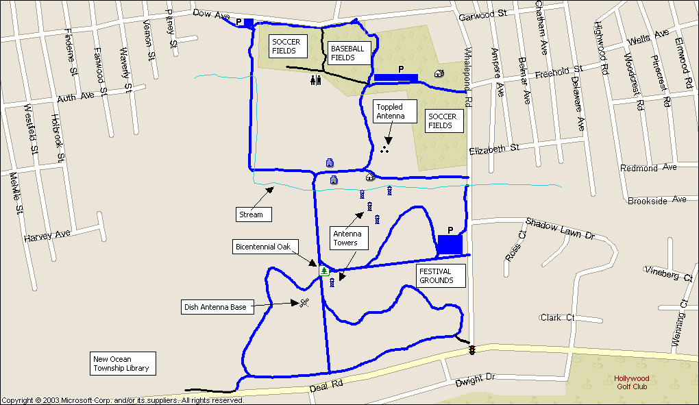
Here is a map of Palia Park with it's internal paved multi use path and various historical artifacts from it's days as a communication testing ground for the army. The history buff might find it interesting that this site was one of the first US wireless stations to track the Soviet Sputnik satellite during the cold war. The concrete base of the dish antenna is still viable, as are a number of rusting antenna towers, one of which is currently home to a very large bird (osprey or bald eagle?). Some of the old laboratory buildings are also still present and used by the township public works department.
Besides providing soccer, and baseball fields, Palia Park serves as the site for July 4th festivities and the long running Ocean Township Italian American Association Festival in Mid August each year. In recent years nationally sanctioned race-walking meets have been held the second weekend in September featuring Olympic class race walking athletes from across the country.
Directions to Palia Park
The Biking
Biking within the park is a pleasure of it's own, it is a great place for children and much safer than riding on the road, at 3 miles it is probably just the right distance for those young one's just getting the training wheels off. I've read of some plans to expand the exisitng trails on the recemtly aquired property where the new library has been constructed.
The township has been separated into 3 cycling routes, each looping through a “named neighborhood”, while there are other neighborhoods (Deal Park, Colonial Terrace, Cold Indian Springs, West Allenhurst, etc) these are the three most recognized, as they correspond to the three elementary schools districts of the same name. Each route has been chosen with safety, maximum distance, rest stops, and township boundaries in mind, for two of the three rides a “short-cut” is available mid-route for those less inclined to tackle the entire distance.
Oakhurst Loop
The safest and shortest ride, at about 5 miles is the Oakhurst loop (cue sheet), which departs from the north-east roadway of Palia Park, and returns at the northern park entrance at the Saul Rubin fields. This 5 mile ride (with a 2 mile short-cut) is almost completely on residential roads with few “fast road” crossings.
This loop heads east and skirts along the neighboring town of Deal before returning back towards a rest stop at fire mans field park (tennis court, playground, rest rooms). The route next brings you back along the northern boundary of Palia Park, where you can make a shortcut into the park and end the loop 2 miles shorter. Continuing past the park brings you towards Scoops Ice Cream, which came be accessed from Dow Avenue via an adjacent tiny strip mall parking lot, if there ever was a reason to bike another two miles, ice cream is it.
Here is a route map. Here is the route in gpx format for your GPS (use save as and save with .gpx extention).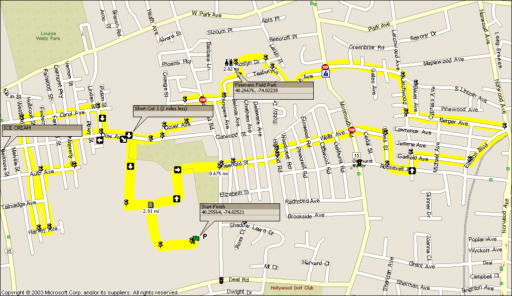
Wanamassa Loop
The Wanamassa loop (cue sheet) provides a longer ride (approximately 8 Ľ miles), and also includes a 2 mile short-cut option. The Wanamassa loop runs on mostly residential roads, although the “ends” near Palia Park contain some short sections where you need to ride on the shoulder of a 35MPH roadway. These “fast” roads carry light traffic, and are suitable for individuals with average bike handling skills, and knowledge of biking open roads.
While Oakhurst is probably the oldest part of the township, Wanamassa is not much younger. Wanamassa contains many older bungalow style homes, and is probably most known by the Wanamassa Fire Company with it's Indian head symbol and yellow fire trucks. The Wanamassa Elementary school is also the oldest school in the township dating back to the 1930's. Joe Palia for whom Palia Park was named was principle of the school before he entered local politics.
The Wanamassa loop runs through the Wanamassa, Deal Park, and West Allenhurst sections of the township, at times skirting along a portions of Deal Lake (largest lake in Monmouth County). There is a rest stop at David Dahrouge Park which includes tennis courts, playground, and bathrooms, a short cut also allows you to "lop off" about two miles of the ride and go directly to the rest stop. Near the rest stop is a 7-11 convenience store on Sunset Ave which can be accessed via Logan Road adjacent to the rest stop. After the rest stop the route returns north to Palia park.
Here is a route map. Here is the route in gpx format for your GPS (use save as and save with .gpx extention).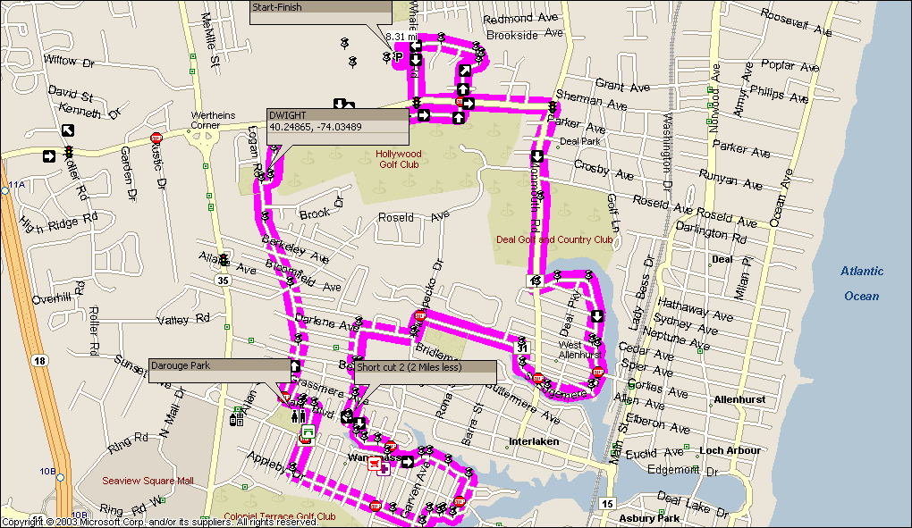
Wayside Loop
The Wayside loop (cue sheet) provides the longest distance (approximately 10 ˝ miles), and traverses the newer developed sections of the township. This ride is for cyclists familiar with riding on road shoulders with vehicles passing at speed. This loop also requires the crossing of highway 35 (twice at a stop light), and navigating an overpass over route 18 that contains entrance and exit ramps. There is nothing out-of-the ordinary for the average road cyclist; however casual riders, children, and those unfamiliar with traffic should avoid this loop.
The Wayside loop begins by first negotiating a crossing of Route 35, a busy divided highway. This is accomplished by crossing at Allaire Avenue, a residential road that crosses the highway and enters into an office/retail area. By traversing the inner roadways it is possible to access Rustic Drive in the Middlebrook apartment complex thereby connecting you with the roadways in the Wayside section of the township. The Wayside loop provides a rest stop at Wayside park where there are bathrooms and tennis courts available. The return trip after the rest stop will bring you through the Cold Indian Springs section of Wayside before rejoining the Middlebrook Apartment/route 35 crossing on the return to Palia Park.
Here is a route map. Here is the route in gpx format for your GPS (use save as and save with .gpx extention).
Getting to the Beach Front
Getting to the beach is easy, there are public beaches in Allenhurst, Long Branch and Asbury Park. Allenhurst is the closest beach with a ride of around 3 miles. To get to the beach follow Roosevelt Avenue all the way to the ocean, from there go north to Long Branch, or south to Allenhurst and Asbury Park. From Asbury Park you can ride the boardwalk to Spring Lake. Most communities allow bikes on the boardwalk before 10AM.
Here is a route map.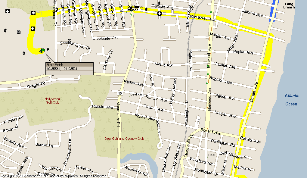