| Jersey Jaunts - Biking in (and around) New Jersey | |
| HOME | |
|
NAV buttons |
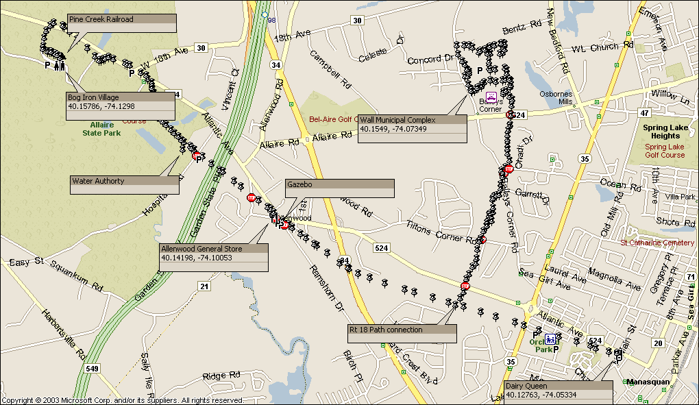
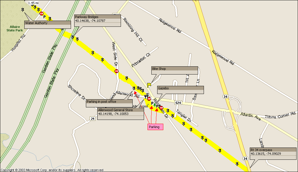
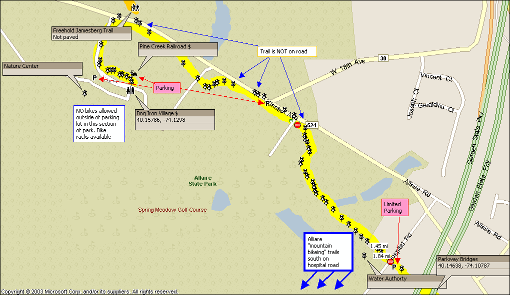
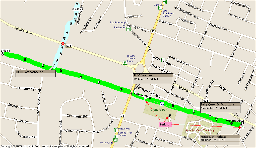
Distance: Approximately 6 miles - Main branch, 2 miles route 18 stub
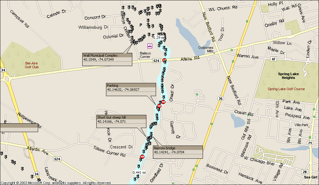
Topology: Graded flat Rail-Trail & gentle rolling (2 miles) Surface: paved 2004, 2005, 2006, 2007, 2008, 2009, 2010 *2009 update* Capital to Coast trail signs are now at both ends of the trail in Allaire, and Manasquan. Spanning from the beach town of Manasquan, to the visitors center at Allaire State park, the Edgar Felix bike path provides a unique destination ride worthy of “racking up” the bikes. The reasonable distance of 5.4 miles and only 4 road crossings with light rural traffic, plus multiple “turn around” points makes this an ideal family friendly ride, adding to the enjoyment is the paved surface of a graded rail bed to make the pedaling easy. The Edgar Felix provides more than just a bike riding opportunity, it provides destinations; a lunch, snack or “antiqueing” stop at the authentic Allenwood general store, a visit to a restored bog iron village, a steam train ride, a road trip to the beach, tennis, play grounds, bridges & over-passes to explore and even an ice cream shop. All these man-made things along with nature’s beauty you'll encounter along the trail. Allaire Trail head ( Allaire State Park with it’s period dressed craftsmen toiling at work in the shops of the restored bog iron village and network of wooded hiking trails provides an excellent turn-around point on the Edgar Felix. While in Allaire you can observe interpretive artisans plying their skills with 18th century tools and techniques in the restored blacksmith, tinsmith, and carpenter shops (admission fee for restored buildings), also in the village you can get a cookie or pastry at the restored bakery, or purchase “dry goods” from the general store. For those inclined to camp & bike, Allaire also contains a campground adjacent to the restored village. Besides the village there is also a nature center with the usual collection of animals & flora representing the local ecology. Before you leave the park catch a ride on a steam train at the Pine Creek Railroad, and see the various locomotives, and cars currently being restored at the maintenance facility. In the spring and summer months you might also witness a wedding taking place in the old church. Don't forget to check out the visitor center to see what bog iron is and how it was made, you'll also find the restrooms there. Note: Bicycles are not allowed beyond the parking area or in the restored village, neither are they allowed on the nature/hiking trails within this “developed” section of the park. The Allaire mountain biking trails are NOT located here, they can be found on Hospital road, a few miles away, ride the Edgar Felix to Hospital road. Route 18 Bikeway Spur (Parking at Wall Municipal Complex, and Baileys corner road crossing) The Route 18 path in Wall Township has been tied into the Edgar Felix about midway between the Route 34 & 35 overpasses; roughly 1.25 miles from the Manasquan trail head. This approximately 1.25 mile trail ends at the Wall Township Municipal complex, while not quite a destination of merit, it does provide safe (the police department is there) and ample parking and serves as a good trail head for the Edgar Felix. The municipal complex itself has a paved trail that runs around the grounds, that you can log another mile or so if you’d like. The Route 18 Bikeway is not a rail bed, but a paved trail that winds (within the right-of-way) through wooded areas, and open fields, since it is not a graded rail bed like the Edgar Felix, the route 18 trail follows the contours of the land providing a meandering feel unlike the Edgar Felix’s straight and narrow. The addition of this trail gives the Edgar Felix “system” a possible 16+ miles of traffic free paved trail to explore (round trip). There are 5 road crossing, two in particular are “fast” roads, but with good sight lines and only two traffic lanes (Atlantic Ave. & Allaire Road). The township has added flashing warning lights that can be activated by push button at all road crossings on the extension, these lights while providing additional safety are seldom needed, as there just isn't that much traffic. Manasquan Trail head (North Main Street, parking across street in municipal lot). On the eastern end of the trail lies the original two miles of the Felix, here you will find tennis courts and playgrounds along the trail as it runs through this residential area. In a small set of stores adjacent to the trail head there is a Dairy Queen and a convenience store where you can grab a sandwich. For those who don’t mind a little “road work”, you can bike to the beach, which is less than 2 miles east of the trail head (follow the “Capital to Coast trail signs). Additional parking and trail access points:
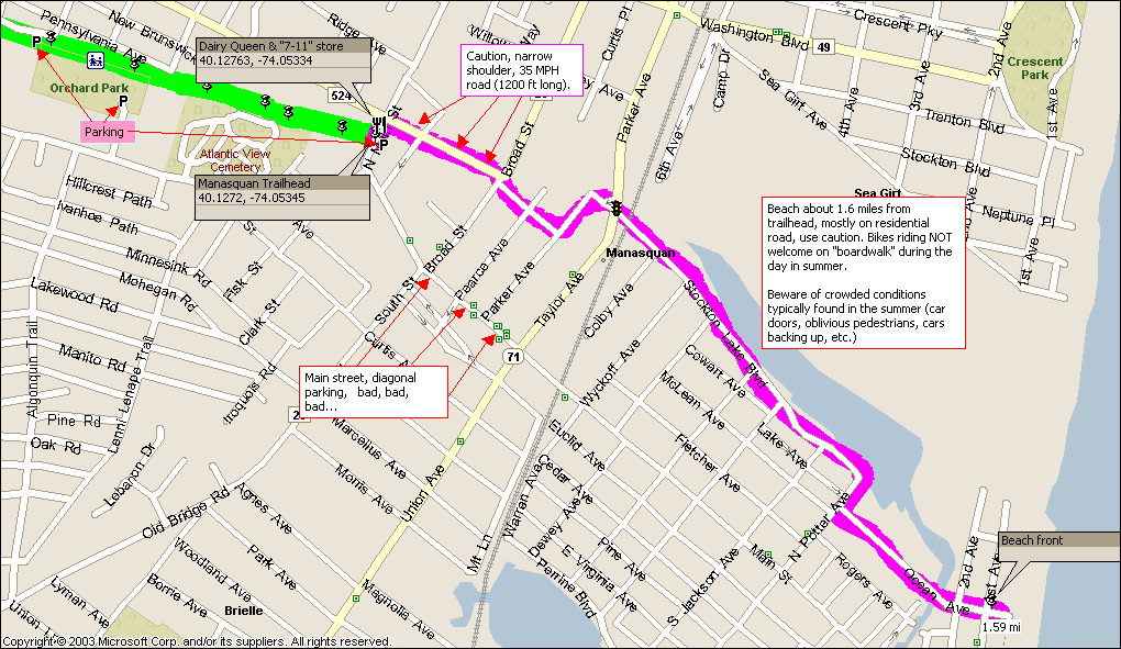
With the Atlantic Ocean just 1.5 miles away you might think to just head east and you’ll find the beach, but that is not entirely true, the need to cross railroad tracks and waterways dictates that you use specific routes. From the trail head the shortest and “safest” route is to take Atlantic Avenue, to Woodland Avenue, left onto Parker, cross route 71 onto Stockton Lake Blvd, and then follow that to Ocean Avenue. Ocean Avenue will take you to the beach. Note: Atlantic Avenue is a county road with narrow shoulders; however you are only on this road for about Ľ mile. History Edgar H. Felix was described by the Asbury Park Press (Jan 3, 1971) as taking “up bicycle riding as a healthful hobby after retirement”. Google searches also show Edgar Felix as a former radio magazine editor during the 1930s and latter as an official with AT&T. In any case Edgar lived in Manasquan and was active in lobbing the town to acquire a portion of the right-of-way for the abandoned Freehold and Jamesburg Agricultural Railroad. On April 4th, 1966, ordinance No. 786 provided $30,000 to acquire the Manasquan portion of defunct rail bed from the Penndel Co of Delaware. Upon completion of the first two miles in 1971 the trail was named in Mr. Felix’s honor. The following year the path was extended through Wall Township, along the right-of-way now held by JCP&L (GPU energy), to Allenwood and terminating at Hospital road. This extension includes the use of existing overpasses for NJ highways 35, 34, and most importantly two bridges over the Garden State Parkway. The establishment of the trail across these two bridges undoubtedly kept pressure to replace the hefty train bridges, albeit with lightweight pedestrian bridges, when the Parkway was widened years later. This is how the trail remained for about 32 years, until the recent significant improvements of the past two years. Around 2004 the trail was extended up to and around the Spring Meadow golf course that now occupies the right-of-way, this extension ended about a mile or so short of Allaire state park, with a very un-friendly narrow shoulder road keeping the Allaire State Park, it’s restored bog iron village, and steam train excursion rides just out of reach. This obstacle was short-lived; in 2005 the trail was pushed all the way into Allaire’s main parking lot. Prior to this recent extension the section from Hospital road to Allaire state park was sometimes referred to as the Freehold Jamesburg trail even though there really wasn’t a trail due to the golf course. I haven’t seen any official announcements that the extension is being called Freehold-Jamesburg, or Edgar Felix. There is a dirt hiking/biking path that continues west of the park along the same right-of-way towards Farmingdale that also bears the Freehold-Jamesburg name, unfortunately it was cut off by the construction of interstate 195 , and now you have to reroute to a road, in addition I don’t believe a trail exists from Farmingdale to Freehold so the Freehold name is a bit misleading (the rail is still active). In keeping with Mr. Felix’s original vision of a trail all the way to Allaire, I have no trouble calling all of it the Edgar Felix trail. In 2005/2006 the expansion continued with a 1.75 mile “spur” trail constructed along the now abandoned NJ route 18 southern right-of-way. This trail is unofficially know as the “Route 18 Bike Path”, and runs from the Wall Township municipal complex (police station, library, etc.) to the Edgar Felix, connecting somewhere between the Route 35 & 34 overpasses. Plenty of parking is available at the municipal complex. Additional Links
|